THE NAME: From Guarani, meaning “place with great rivers”
THE PEOPLE: The Paraguayans
GEOGRAPHY:
The Paraguay River divides the country into two disparate regions:
East: rolling terrain, with wooded hills, tropical forests, and fertile grasslands
West: the Chaco, a semi-arid Hat region
Max. altitude: 850 m. (2,720 ft.) (Cerro San Rafael)
Area: 406,752 sq. lan. (157,048 sq. mi.)
Density: 7.9 pers./sq. lan. (21 pers./sq. mi.) (1986)
Arable land: 5% (1987) Forest: 50%
Climate: Subtropical with abundant rainfall and only a short dry season from July to September, when temperatures are lowest.
HISTORY
Originally inhabited by the Guarani Indians
1524: Arrival of Spanish explorer Alejo Garda
1528- 31: Exploration by Sebastian Cabot
1537: First Spanish settlement in Asuncion
1776: Establishment of Viceroyalty of the Rio de la Plata
May 14,
1811: Independence and rejection of Buenos Aires’ leadership
1865-70: Defeated in war against the Triple Alliance (Argentina, Brazil, and Uruguay); loses 55,000 square miles of territory and more than half its population
1932–35: Chaco War; Paraguay settles boundary dispute with Bolivia
1954–S6: Military coup; General Alfredo Stroessner assumes power; has been reelected since.
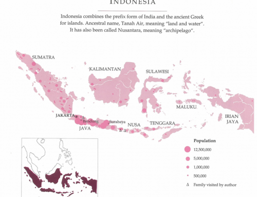
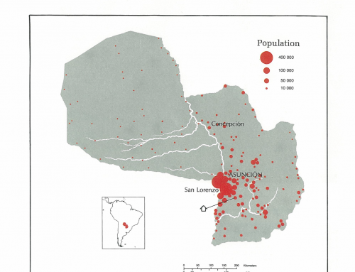
Capital: Asuncion, pop. 457,210 (1982)